Documenting North America's past & present covered bridges


Home

Long, Franklin County

If you find errors in the data please contact Bill Caswell.

If you would like to provide information on covered bridges that no longer exist from your state, or adopt a state to work on, we would certainly welcome your assistance. Please contact Trish Kane for more information.

Inventory Number: VT/45-06-35x
County: Franklin County
Township: Sheldon
Town/Village: Sheldon Junction
Bridge Name: Long
Crosses: Missisquoi River
Truss type: Burr
Spans: 4
Length:
Roadway Width:
Built: 1887
Builder:
When Lost: 1927
Cause:
Latitude: N44 54.10
Longitude: W072 57.13
See a map of the area
Topographic map of the area
Directions:

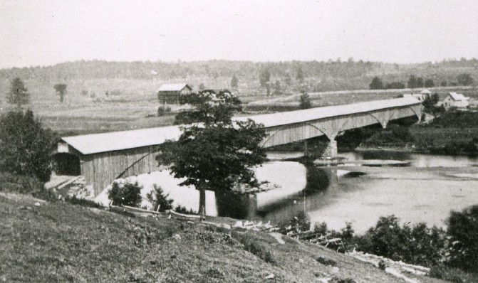
Long Bridge, Sheldon, Franklin County, VT Lost 1927
Richard Sanders Allen Collection, NSPCB Archives
Comments:
Per the St. Albans Daily Messenger and Advertiser, March 25, 1884, "...the selectmen have called the town together to see if the town will build a new bridge across the Missisquoi river, near the fair grounds [VT/45-06-35]. The town is bonded for the L.M.V.R.R. for $44,000, which is thought to be sufficiently large for this small town without adding the building of a new bridge, and the voters, no doubt will so order by 7 to 1.----The town supports a covered bridge near Olmsted Falls [VT/45-06-36], and another near the residence of B. Fisk, North Sheldon [VT/45-06-49]----both across the Missisquoi river; also a covered bridge in the village of Sheldon [VT/45-06-34], and another at the mouth of Black Creek where it empties into the Missisquoi river [VT/45-06-54].----We understand there is another petition out to build a new bridge near the residence of J. G. Emery [VT/45-06-38]." Per The Burlington Free Press, September 13, 2017, "In 1887 the state of Vermont built a bridge across the Missisquoi River near Sheldon Junction. This was two-span bridge 148 feet long. The cost was approximately $13,000. This bridge fell in the flood of 1927. It crossed the Missisquoi River from the now 'Casino Road' to the former 'Main Street.' The former Main Street ran along the river, under the CVRR Railroad bridge and continued along the river to the intersection with the Bouchard Road and then into the village."
Sources:
The Burlington Free Press, September 13, 2017.
St. Albans Daily Messenger and Advertiser, March 25, 1884.

Compilation © 2024 Covered Spans of Yesteryear

The images in this collection may be protected under copyright law and may only be used for educational, teaching, and research purposes.
If the intended use is beyond these purposes, it is the responsibility of the user to obtain the appropriate permissions from the owner stated in the image's credits.


Home | Copyright Notice | Reports | Credits | Unidentified Bridges | FAQ | Links

www.lostbridges.org