Documenting North America's past & present covered bridges


Home

Columbia Wrightsville #2, Lancaster County

If you find errors in the data please contact Bill Caswell.

If you would like to provide information on covered bridges that no longer exist from your state, or adopt a state to work on, we would certainly welcome your assistance. Please contact Trish Kane for more information.

Inventory Number: PA/38-36-129x / PA-67-45x
County: Lancaster County / York County
Township:
Town/Village: Columbia - Wrightsville
Bridge Name: Columbia Wrightsville #2
Crosses: Susquehanna River
Truss type: Burr
Spans: 27
Length: 5612', 5620'
Roadway Width: 40'
Built: 1834
Builder: James Moore
When Lost: 28 Jun 1863
Cause: Burned
Latitude: N40 01.76
Longitude: W076 31.06
See a map of the area
Topographic map of the area
Directions: Located about 1/8 mile downstream from the first Columbia-Wrightsville Bridge.

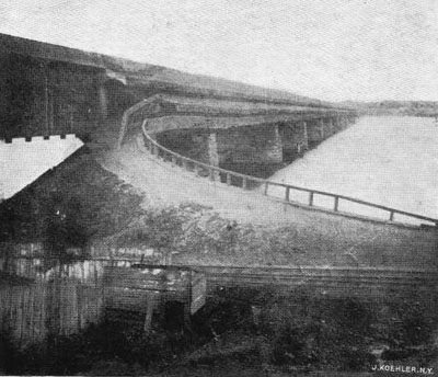
Columbia Wrightsville Bridge, Columbia-Wrightsville, PA Built 1834 Burned 28 Jun 1863
Thomas G. Kipphorn Collection
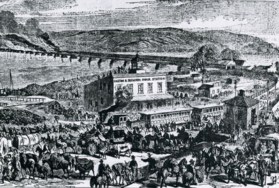

Columbia Wrightsville Bridge, Columbia-Wrightsville, PA Built 1834 Burned 28 Jun 1863
Thomas G. Kipphorn Collection

Comments:
The first covered Columbia-Wrightsville Bridge was built in 1813. The Slaymaker brothers built the masonry and the bridge was built by Jonathan Walcott with the total cost at $231,771.00. At 5,690', this was the longest covered bridge ever built in the world. The clear span was 5,678', with a 30' double lane roadway, a 14'6" clearance and the height from water was 27'. There had been some conflicting data on the characteristics of the truss type and number of spans, depending on three different sources. At the Susquehanna Heritage website, it’s listed as a 54-span Burr truss: https://www.susquehannaheritage.org/riverroots-bridging-the-susquehanna/ A document published in Harrisburg in 1822, which was a compilation of the results of a survey done all over the state on bridges, tends to back this up. The answers submitted by the company were brief but clear: 30 feet wide, 5,690 feet long. Number of piers and "arches" (spans) 53. Material of piers, stone. Not painted. Roofed. No footways. Cattle permitted at one time, 40-50. Commenced 1812, completed 1814. It was oriented east-northeast to west-southwest between the towns of Columbia in Lancaster County and Wrightsville in York County. The ends of the bridge would have lined up with Linden Street in Columbia if an imaginary line is extended straight down to the river. On the Wrightsville side, it would have lined up with Vine Street, again if an imaginary line is extended straight down to the river, although neither of these roads led to the bridge. On February 3rd & 4th, 1832, five spans went out in an ice freshet. Several days later, the entire bridge was swept away. Coordinates were gathered by drawing an imaginary line from Linden and Vine Streets at the approximate center. The second covered bridge connecting Columbia & Wrightsville was built in 1834 by James Moore at a cost of $128,726.00 with twenty-six Burr Truss spans. Total length came to 5,620'. The clear span was 5,612', with a 40' double lane roadway, a 20' clearance and the height from water was 25'. It was oriented east-northeast to west-southwest on the line of existing stone piers on the upstream (north) side of the Route 462 (SR0462) multi-arch concrete bridge between Columbia and Wrightsville and about 1,545' downstream from Columbia - Wrightsville Bridge #1 (PA/38-36-128x and 38-67-44x) until destroyed by fire set by the Union Army, after a failed attempt to dynamite the 4th span from the Wrightsville end, to prevent Confederate troops from crossing into Lancaster County on Sunday, June 28, 1863. Coordinates are at the approximate center of the line of empty piers. The third covered bridge was oriented east-northeast to west-southwest on the same piers that held bridge #2. The reason it was documented as a bit shorter was that the first span from the York County abutment to the first pier was an open structure, but the length of the entire structure would have matched Bridge #2. It also had two wrought iron through truss spans in the center, with the idea of reducing any fire loss by one half. It was built in 1869 by the Pennsylvania Railroad at a cost of $400,000.00. The twenty-six span Howe Truss with auxiliary arches had an overall length of 5,390', with a clear span of 5,384', a 40' roadway, a 20' clearance and stood 25' above water. The bridge stood until destroyed by a hurricane on September 30, 1896. Every span, except the two iron firebreak spans were thrown down into the river. It was replaced by a two tiered wrought iron bridge on the same piers and this bridge stood until dismantled and sold for scrap during the summer of 1964. Coordinates are at the approximate center of the line of empty piers.
Source:
Kipphorn, Thomas. Information received by email, September 2005

Compilation © 2024 Covered Spans of Yesteryear

The images in this collection may be protected under copyright law and may only be used for educational, teaching, and research purposes.
If the intended use is beyond these purposes, it is the responsibility of the user to obtain the appropriate permissions from the owner stated in the image's credits.


Home | Copyright Notice | Reports | Credits | Unidentified Bridges | FAQ | Links

www.lostbridges.org