| Inventory Number: | PA/38-32-24x / PA-65-17x | | County: | Indiana County / Westmoreland County | | Township: | Burrell - Derry | | Town/Village: | Blairsville - Bairdstown | | Bridge Name: | Bairdstown or Blairsville | | Crosses: | Conemaugh River | | Truss type: | Wernwag | | Spans: | 1 | | Length: | 300' | | Roadway Width: | | | Built: | 1822 | | Builder: | James Moore | | When Lost: | 22 Jan 1874 | | Cause: | Collapsed | | Latitude: | N40 25.82 | | Longitude: | W079 16.20 | | See a map of the area
Topographic map of the area | | Directions: | At the west end of Market Street (SR2002 - LR32179) in Blairsville, Indiana County and Bairdstown Road (SR1016 - LR64264) in Bairdstown, Westmoreland County. |
|
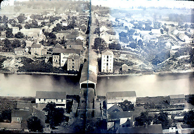
Bairdstown or Blairsville Bridge, Burrell-Derry, Indiana County, PA. Built 1822 Collapsed 1874
Fred Yenerall Collection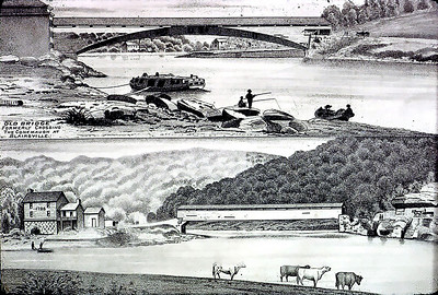
Bairdstown or Blairsville Bridge, Burrell-Derry, Indiana County, PA. Built 1822 Collapsed 1874
Fred Yenerall Collection
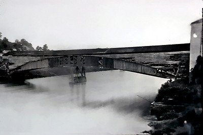
Bairdstown or Blairsville Bridge, Burrell-Derry, Indiana County, PA. Built 1822 Collapsed 1874
Fred Yenerall Collection
|
Sources:
Caldwell, J. A., 1745-1880. History of Indiana County Penn'a., Newark, Ohio, 1880.
Storey, Henry Wilson, History of Cambria County, Pennsylvania, The Lewis Publishing Co., New York, 1907.
Leathers, Dorie S., Country Crossings, Indiana County's Covered Bridges, The Historical & Genealogical Society of Indiana County, PA, 2008.
Moll, Fred J.. Pennsylvania's Covered Bridges - Our Heritage, 2004, pages 138-139
Kipphorn, Thomas. Information received by email, June 2007 |